
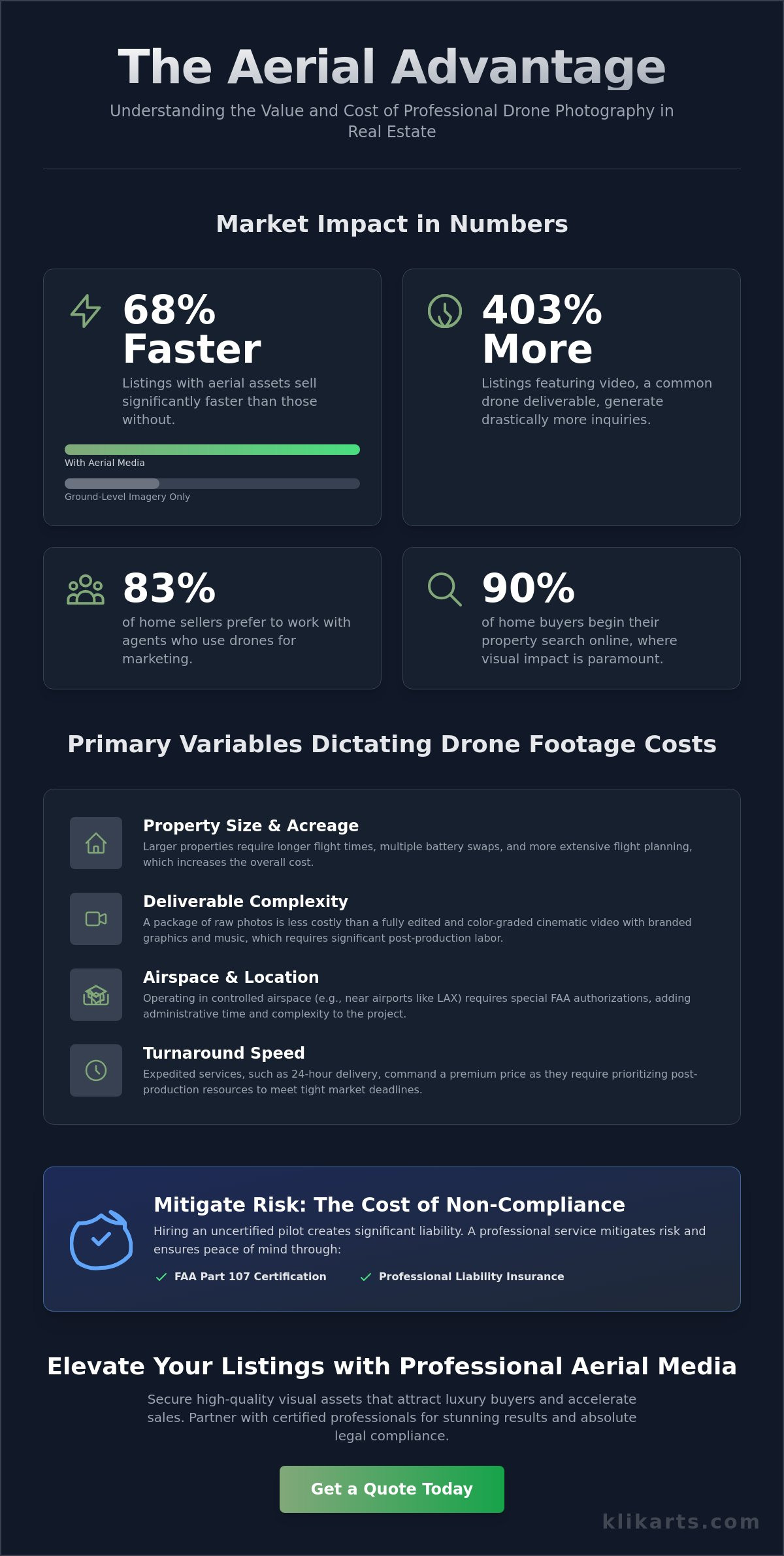
Did you know that 83% of home sellers now prefer to work with agents who utilize aerial media to market their properties? In a market where 90% of buyers start their search online, the perspective from the sky has moved from a luxury perk to a strategic requirement. As you evaluate your marketing budget, you likely want to know how much real estate agents pay for drone footage to ensure you’re making a sound investment. High-quality aerial assets can help listings sell up to 68% faster, but the total investment depends on technical precision and the specific deliverables your listing requires.
You likely recognize the necessity of high-impact visuals but want to avoid overpaying for simple shots or risking legal complications with the FAA. It’s frustrating when slow turnaround times or compliance concerns stall your momentum in a competitive market. This comprehensive guide from Klikarts Photography provides a clear breakdown of modern pricing structures and the key factors that drive professional costs in 2026. You’ll discover how to secure high-quality visual assets that attract luxury buyers while maintaining absolute legal peace of mind. We will explore the relationship between technical complexity and market value so you can maximize your ROI on every listing.
Key Takeaways
- Understand why aerial media has become a baseline requirement for establishing property prestige and neighborhood context in the 2026 market.
- Identify the primary technical variables, such as property acreage and deliverable complexity, that determine exactly how much do real estate pay for a drone footage.
- Evaluate different professional pricing structures, including flat-fee packages and tiered services, to optimize your marketing spend.
- Learn how to mitigate brokerage liability by verifying FAA Part 107 compliance and professional insurance coverage before every flight.
- Discover the strategic advantage of integrating aerial visuals with 3D floor plans and video walkthroughs to create a comprehensive listing experience.
Understanding the Investment: Why Real Estate Professionals Pay for Drone Footage
In 2026, the digital storefront is the primary point of contact for nearly every home buyer. High-performance agents recognize that aerial media is no longer a visual upgrade; it’s a strategic necessity. When evaluating how much do real estate pay for a drone footage, it’s essential to view the cost through the lens of market acceleration. Listings featuring professional aerial assets sell approximately 68% faster than those relying solely on ground-level imagery. This efficiency is driven by buyer psychology. A bird’s-eye view provides immediate property context, establishing neighborhood prestige and proximity to key landmarks that a standard wide-angle lens cannot capture.
Historically, Aerial photography was reserved for high-end cinematic productions or large-scale mapping. Today, it’s a baseline expectation for residential marketing. Data from REA Group indicates that listings with video generate 403% more inquiries. In competitive hubs like Los Angeles, drone footage has shifted from a luxury perk to a standard requirement. Buyers expect a comprehensive visual narrative before they commit to a physical walkthrough. Agents who fail to provide this perspective often see their listings linger on the market while tech-savvy competitors capture the attention of high-intent buyers.
The Competitive Advantage of Aerial Perspective
Aerial views do more than look impressive. They define property boundaries and highlight proximity to coastlines or local amenities with absolute clarity. This perspective captures the lifestyle element of a home, showing how the pool relates to the patio or how the lot sits within the cul-de-sac. By providing this level of detail upfront, agents effectively filter for serious buyers. Those who schedule a showing are already sold on the layout and location, which streamlines the sales cycle and reduces wasted time for both the seller and the agent. It creates a feeling of transparency that builds trust with luxury clientele.
Beyond Pretty Pictures: Functional Uses for Drones
Modern drone services provide utility far beyond marketing aesthetics. Professional providers now utilize tools like Drone Deploy for high-precision property measurements and site planning. This technology allows agents to document roof conditions or showcase large-scale acreage features with topographical accuracy. For new developments, aerial mapping and 3D property rendering provide a competitive edge by allowing potential investors to visualize the finished project within its actual environment. When agents ask how much do real estate pay for a drone footage, they must account for these technical applications that provide tangible value during the due diligence and site evaluation process. These assets serve as a permanent record of the property’s state at the time of listing, offering security and clarity for all parties involved.
Primary Variables That Dictate Aerial Media Costs
Determining exactly how much do real estate pay for a drone footage requires an analysis of the specific logistical hurdles of a project. Pricing isn’t arbitrary. It’s a calculated response to technical risk, flight time, and post-processing labor. A standard suburban lot involves significantly less flight planning than a 50-acre estate or a complex multi-unit residential development. Larger properties require more battery swaps and extensive coverage to ensure every boundary is documented with precision. The National Association of REALTORS® emphasizes that regulatory considerations are a major factor in professional operations. In markets like Los Angeles, securing flight authorizations for restricted airspace near LAX or Burbank adds a layer of administrative labor that hobbyist pilots often overlook.
Turnaround speed is another critical factor. In a market where timing is everything, waiting a week for media can stall a listing’s momentum. Professional firms often provide 24/7 emergency photography services for agents who need to move at the speed of the market. This level of reliability ensures that your listing hits the portal with high-quality visuals while interest is at its peak. When you ask how much do real estate pay for a drone footage, you’re often paying for the certainty that your assets will be ready when the contract is signed.
Property Scope and Geographic Challenges
Los Angeles presents unique geographic challenges that influence project difficulty. Flying in the winding canyons of the Hollywood Hills requires different technical skills and safety protocols than capturing a wide-open beach property in Malibu. Canyons often present signal interference and landing challenges, while coastal areas may deal with higher wind speeds. Regional brokers must also consider travel fees for multi-location shoots. A professional team calculates these risks into the initial quote to ensure the safety of the property and the quality of the final assets.
Technical Deliverables and Post-Production
The type of deliverable is frequently the most significant cost driver. There’s a vast difference between raw clips and a fully edited highlight reel featuring professional color grading and music. High-resolution stills require meticulous image enhancement to ensure lighting is perfect across all frames. Advanced projects might include 3D floor plans or precise Drone Deploy measurements for site planning. Integrating these aerial views with interior listing video walkthroughs creates a seamless, immersive experience for the buyer that ground-level photography simply cannot match.
Common Pricing Models for Professional Drone Services
Professional drone operations have moved away from confusing hourly rates toward structured, value-driven pricing models. When calculating how much do real estate pay for a drone footage, agents should prioritize predictability over variable costs. The most common approach is the flat-fee model, which provides a fixed price for a specific set of deliverables. This allows for precise marketing budget management without the risk of unexpected overages due to flight delays or extended editing time. Many top-producing teams prefer tiered service packages that bundle aerial photography with twilight shots and interior listing video walkthroughs. This comprehensive approach ensures a cohesive visual narrative across the entire marketing campaign.
High-volume brokerages often opt for subscription or retainer models. These agreements provide a consistent flow of high-quality assets at a prioritized schedule, ensuring that every listing in the firm’s portfolio maintains a premium standard. The National Association of REALTORS® drone guidelines highlight that regardless of the pricing model, professional compliance remains a non-negotiable factor. Choosing an a la carte approach allows agents to add specific drone assets to existing photography orders, providing flexibility for smaller listings that still require an aerial perspective.
Standard Residential vs. Luxury Estate Packages
Standard residential packages typically focus on 5 to 10 high-resolution images that showcase the roof, lot boundaries, and neighborhood context. In contrast, luxury estates in exclusive enclaves like Bel Air demand a Luxury Standard that includes 4K video clips, specialized social media edits, and twilight aerials. These properties require more sophisticated equipment and extended flight time to capture the scale and architectural nuance expected by high-net-worth buyers. The complexity of these shoots often involves multiple flight paths to ensure every vantage point is perfectly framed.
Value-Added Technical Services
Technical depth also influences the final invoice. Specialized Drone Deploy property mapping and 3D property rendering provide essential data for large-scale developments or commercial listings. These services require specialized software and advanced pilot expertise to produce accurate, georeferenced results. Additionally, the speed of the market often necessitates 24/7 emergency photography services. While last-minute bookings or tight turnaround requirements influence the final cost, the ability to secure professional assets within a 24-hour window provides a significant competitive advantage in a fast-moving real estate market.
Mitigating Risk: The Cost of Non-Compliance and Low-Quality Footage
While price is a major consideration, focusing solely on the lowest bid often leads to significant long-term expenses. When agents evaluate how much do real estate pay for a drone footage, they must factor in the cost of risk mitigation. Hiring an unlicensed pilot is not just a quality risk; it’s a legal liability for the brokerage. Commercial drone operations require a current FAA Part 107 Remote Pilot Certificate. Operating without this certification is a violation of federal law and, crucially, voids most insurance policies. A single accident on a property without coverage can result in catastrophic financial consequences that far outweigh any initial savings on marketing fees.
Equipment reliability also separates professional firms from hobbyists. Consumer-grade drones often struggle with signal stability and camera dynamic range. In contrast, professional cinematic platforms provide the stability and clarity required for high-end listings. If the initial footage is shaky, poorly lit, or fails to meet the expected standard, you face the “do-over” cost. This involves paying for a second, more expensive professional shoot to fix the mistakes of the first. Beyond the legal risks, the quality of the output dictates how much do real estate pay for a drone footage in terms of total marketing ROI. Investing in professional competence the first time protects your budget and your timeline.
Legal and Financial Liability for Realtors
The FAA can impose significant fines on both the pilot and the agent who hired them for unauthorized commercial flights. In the complex airspace of Los Angeles, this risk is magnified. Professional pilots possess specific expertise in navigating restricted zones and coordinating with local air traffic control. This technical knowledge ensures your project stays compliant while maintaining your reputation for excellence. Reliable partners prioritize safety protocols so you don’t have to worry about listing delays or legal scrutiny. Professionalism provides the peace of mind that your business is protected.
Post-Production and Branding Consistency
Your marketing materials are a direct reflection of your brand identity. Shaky or amateurish aerial clips can instantly diminish the perceived value of a luxury property. Professional video editing and image enhancement ensure that your drone assets match the high standard of your interior photography. Visual cohesion is essential for attracting sophisticated buyers who expect perfection. To ensure your listings meet these rigorous standards without the risk of non-compliance, you should partner with a certified aerial media expert who understands the high stakes of the real estate industry.
Optimizing Your Marketing Budget with Klikarts Aerial Solutions
Maximizing the impact of your marketing budget requires more than just hiring a pilot; it demands a partnership with a strategic expert. While understanding how much do real estate pay for a drone footage helps you set a baseline, the true value lies in the conversion rate of the final assets. Klikarts Photography integrates 24/7 emergency photography services with advanced drone technology to ensure your listings are market-ready at a moment’s notice. We don’t just capture images. We leverage our real estate brokerage background to identify the specific angles and features that drive buyer engagement and accelerate the sales cycle.
The synergy between different media types is where top-producing agents find the most significant ROI. By combining high-resolution aerial photography and video with detailed 3D floor plans, you provide a comprehensive spatial narrative that ground-level shots cannot achieve alone. This integrated approach streamlines the buyer’s journey, allowing them to understand the property’s layout and its relationship to the surrounding environment simultaneously. When you evaluate how much do real estate pay for a drone footage, consider the efficiency of a single-source provider that handles everything from image enhancement to complex video production with high-performance precision.
The Klikarts Advantage in Los Angeles
Los Angeles real estate requires a nuanced understanding of local aesthetics and neighborhood prestige. Our team possesses deep expertise in capturing the distinct visual appeal of Santa Monica, Malibu, and Beverly Hills. We utilize Drone Deploy measurements to provide developers and high-end residential agents with unparalleled accuracy for site planning and lot documentation. This “high-performance consultant” approach ensures that every flight serves a specific strategic purpose. We focus on technical precision and visual excellence to deliver a competitive edge that generic providers simply cannot replicate.
Next Steps: Booking Your High-Resolution Aerial Session
Before requesting a quote, evaluate the specific needs of your listing. Consider the property’s scale, the complexity of the surrounding airspace, and the type of deliverables required to attract your target demographic. Our streamlined booking process is designed for maximum efficiency, respecting the fast-paced nature of the Southern California market. With our 24/7 availability for urgent LA listings, you can secure professional media assets exactly when you need them. Take the next step in your marketing strategy and elevate your listing with Klikarts Photography today. Our commitment to reliability and results-oriented media makes us the essential component of a successful professional strategy.
Elevate Your Listing Strategy with Professional Aerial Media
In the 2026 real estate market, the perspective from the sky has become a standard requirement for competitive listings. Success depends on moving beyond basic snapshots to secure high-impact visual assets that drive buyer engagement. Determining how much do real estate pay for a drone footage is the first step toward building a high-performance marketing suite that captures attention and accelerates sales. By prioritizing technical precision, FAA Part 107 compliance, and rapid delivery, you protect your brokerage from liability while maximizing your property’s market value.
Klikarts provides the expert partnership you need to navigate these variables with absolute confidence. Our team combines advanced Drone Deploy property measurements with 24/7 emergency service availability to ensure your marketing remains uninterrupted. We focus on delivering visual excellence that translates into measurable results for your clients. Your listings deserve a professional standard that reflects their true value. View Our Premium Drone and Photography Packages to see how we can transform your next listing. We look forward to helping you dominate your local market with superior aerial media.
Frequently Asked Questions
Is drone footage really necessary for smaller residential listings?
Aerial media is essential for smaller residential listings because it establishes the property’s context within the neighborhood. It effectively showcases the lot size, yard layout, and proximity to local landmarks or amenities like parks and schools. This perspective provides a comprehensive view of the property footprint that ground-level photography cannot replicate. By offering this clarity upfront, you attract more qualified buyers who are already satisfied with the home’s location and surroundings.
Does a drone pilot need a special license to shoot real estate in Los Angeles?
Every commercial drone operator must hold a current FAA Part 107 Remote Pilot Certificate to legally shoot real estate. In Los Angeles, this requirement is particularly critical due to the complex restricted airspace surrounding major hubs like LAX and Burbank. Hiring an unlicensed pilot is a violation of federal law and can result in significant fines for both the pilot and the hiring agent. Professional certification ensures the pilot understands how to secure necessary flight authorizations safely.
How much time does a typical real estate drone shoot take on-site?
A standard residential drone shoot typically takes between 30 and 60 minutes on-site. This window allows the pilot to conduct a thorough safety sweep, plan optimal flight paths, and capture a full suite of high-resolution stills and 4K video clips. Larger estates or complex commercial parcels requiring detailed technical mapping will naturally take longer. The total duration depends on the property acreage and the specific deliverable requirements of your marketing strategy.
What happens if the weather is bad on the day of the drone shoot?
Safety is the primary consideration for all aerial operations, so shoots are typically rescheduled if conditions involve high winds, rain, or low visibility. Professional firms monitor weather patterns closely to anticipate disruptions and coordinate new timeslots as efficiently as possible. Rescheduling ensures the safety of the property and the equipment while guaranteeing the highest visual quality for your listing. Most providers prioritize these makeup sessions to keep your marketing timeline on track.
Can drone footage be used for property boundary and measurement accuracy?
Drone technology is highly effective for documenting property boundaries and site measurements when using specialized software like Drone Deploy. This allows pilots to create georeferenced maps and 3D models with high technical accuracy. When agents evaluate how much do real estate pay for a drone footage, they often find the added value of these technical mapping assets justifies the investment. These tools are invaluable for developers and buyers of large land parcels or commercial developments.
Do I need to notify the neighbors before a drone shoot takes place?
You aren’t legally required to notify neighbors for flights occurring over the subject property, as the FAA maintains authority over the national airspace. However, informing adjacent residents is considered a professional best practice that helps prevent misunderstandings. This proactive courtesy ensures the shoot proceeds smoothly without interruptions or privacy concerns from the community. Brief communication with neighbors reinforces your reputation as a considerate and professional agent who values transparency.
What is the difference between raw drone footage and edited real estate video?
Raw drone footage consists of uncompressed, flat files directly from the camera sensor that lack professional polish and branding. Edited real estate video is a finished marketing asset that includes color grading, stabilization, music, and professional sequencing. The editing process is what transforms basic aerial clips into a compelling visual narrative that attracts luxury buyers. High-quality post-production ensures that your aerial assets align perfectly with your brand’s standards and interior photography.
How quickly can I expect the final edited drone photos and video?
Professional media firms typically deliver final edited drone photos and videos within 24 to 48 hours of the flight session. Speed is a critical factor in markets like Los Angeles, where listings must hit the portal while interest is at its peak. Efficient workflows and dedicated editing teams ensure that your high-resolution assets are ready for the market without unnecessary delays. This rapid turnaround allows you to maintain momentum and begin your digital marketing campaign immediately.